Top predators play crucial roles in balancing marine food-webs through top-down pressure on the species they prey upon. Their presence at an area of sea is usually a very visual signal that those waters provide the conditions necessary for the survival of these animals. While being ecologically important these predators, which include cetaceans and seabirds, are also highly charismatic attracting both attention and affection from wide swathes of the public. Economically, top predators may also contribute to local economies through bird watching or whale and dolphin watching excursions, or via the purchases of equipment or holiday bookings and day trips. But as our coastal waters become more in demand from a range of existing and developing users there is a danger of conflict between the various interests.
Quantifying the distribution and populations sizes of cetaceans and seabirds is thus considered paramount among the regulatory bodies charged with preserving these ecologically and socioeconomically important species. However knowledge of seabirds away from known nesting colonies, or understanding of cetaceans remote from the few ‘resident’ populations has been sparse, so only a partial picture of their annual cycles and activities has been available. This is a symptom of the highly mobile nature and extensive ranges of cetaceans and seabirds, which need quantifying at annual, seasonal and continental scales. Over the last decade there has been an increase in research involving sea surveys but to date individual surveys have restricted spatial and temporal coverage, thus applying the results has been limited. Large numbers of individual surveys have been combined to overcome some of the difficulties but there remains the challenge that differing survey methods and biases in spatial and temporal coverage make then unsuitable for analysis using conventional approaches.
Seabird and cetacean distributions - a step change
MERP scientists, working with colleagues across thirty-three academic, governmental, non-governmental, and voluntary organizations representing a dozen countries that share our waters, undertook a major project to collate a huge data resource of observations in the north-east Atlantic, covering seas from Norway to Portugal. The study looked at data resulting from 2.19 million km of cetacean surveys and 1.36 million km of seabird surveys. This comprised 226,000 hours of aerial and vessel surveys, covering 2148000km2 and 127 species. From this by using novel applications of existing approaches to overcome the recognised challenges, density surfaces for the 12 most common seabirds and the 12 commonest cetacean species, at 10K and monthly resolutions over 32 years were produced. This represents the largest collation and analysis of data for this region. Bringing the disparate survey data together required standardisation including estimates of the variance between different observation platforms such as aircraft, small and large vessels, whether transects were line or strip approaches, and of course sea states at the time of observations, all of which can effect observation accuracy and compatibility. Species distribution models were used that took into account environmental variables likely to influence the biogeographical range of species and the ability to predict encounters with, and potential aggregations of animals that could be predicted, if encountered. Distributions and numbers in time and space matched expectations from previous studies, while population estimates were also considered reasonable.
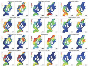
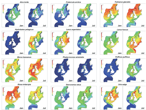
This study is the most comprehensive collation and analysis of at-sea surveys for the north-east Atlantic and represents a transformative step in our understanding of where and when these top predators are to be found. The collated data and the understanding of the factors influencing top predator distribution in space and time, provide robust input into ecosystem models. The highly detailed maps for each of the twelve species included will form the basis for developing risk maps of the cumulative effects of different human pressures on individual species, and hence on general biodiversity; these are expected in the next 2 years. These maps across seasons and geographical areas are likely to be most immediately useful for stakeholders concerned with MPAs, MSFD indicators, and marine management including offshore renewable energy installations’ effects and risks posed from bycatch, shipping and offshore developments.
Porpoises, turbines and tidal streams.
 As the tides rise and fall horizontal movements of water also occur and can in some locations be quite powerful, providing ideal locations for tidal stream energy devices and hence of great interest to the industry. However, tidal streams are also known to be attractive to prey species which because of higher concentrations and because they are contained and easier to catch are favoured foraging grounds for marine predators such as harbour porpoise. Inevitably when sharing the same space, there is room for negative impacts if the devices and the porpoises are in the same place, so MERP scientists set out to discover exactly how, where and when the animals used the tidal streams for hunting. They looked at the local and regional hydrodynamic properties of a number of locations and found that porpoises were concentrated in small areas, and increased as the tide ebbed. In areas where current speed was higher they were encountered where shear lines develop and in shallower water. The results support the idea that combined regional and local hydrodynamic characteristics can at least partially explain occupancy, with a leaning towards, reduced current speeds. Other variables which affect occupancy by prey and hence porpoises still need to be studied but the indications suggest that placing turbine sites in areas of high current speeds and where laminar currents occur, should minimise encounters between porpoises and turbines and coincidentally where energy extraction is maximised. So it may be that there will be little need for compromise from industry when it comes to siting turbines for the greatest energy extraction.
Seabird diets
 While there is good information about breeding sites for our seabirds and in other MERP research data concerning distribution of seabirds and cetaceans at sea has been collated to form useful distribution maps, another gap in our knowledge, as identified by the RSPB, is diets. Now MERP researchers have brought together all available information into a comprehensive time- and spatiallyexplicit database of diets for the 10 most common seabird species around the British coast. Such information is important for conservation and management strategies which aim to safeguard the food base of these birds. There are of course, still gaps in our knowledge, and interpolation from existing databases of what the birds eat and the distributions in time and space and abundance of their prey items will go some way to filling them. This MERP activity has enhanced previous knowledge greatly and in the spirit of the programme is already being embraced and used by other MERP research projects. Not least is its importance in being unique as top end trophic level information, and so contributes to understanding of how ecosystems are regulated by top down/bottom up processes. Changes at lower trophic levels will have impacts on seabirds (and other top predators), in turn this has consequences for planning and ‘future proofing’ of MPAs. An example is the distribution of the sandeel, an important forage fish, the decline of which has been attributed to causing declines in some seabirds. This is the subject of further studies by MERP partners.
Top predators put the pressure on
 Knowing how much predation pressure is exerted by seabirds around their colonies, and where this pressure is taking place in UK waters is essential for informing interactions with human activities such as fishing, offshore renewable energy development and conservation areas. MERP scientists working with the RSPB have continued to develop an energetics modelling framework for mapping predation pressure from UK seabird breeding colonies. RSPB research and observations have led to the development of a method to empirically estimate how seabirds utilise the resources. GPS tracking data has been applied to three important, colonial cliff-nesting species: black-legged kittiwakes, common guillemot and razorbill. Knowing how much energy each species needs at the breeding colony lies in developing an energetics model that considers energy intake/hour of foraging, time-activity budgets and subsequent adult and chick survival. The model is combined with estimates of adult and chick survival to estimate prey intake/hour of foraging. It is now possible to obtain speciesspecific estimates for these parameters around the UK with the ultimate aim of producing predation pressure maps for the three species in UK waters. As with other MERP research the results of this study feeds into other aspects within the MERP consortium. When these maps are published they will be enable assessment of key habitat areas used by breeding seabirds, which can be overlaid with maps of other marine pressures, they will identify regions and areas where strong trade-off occurs between competing human and wildlife activities. It is anticipated that the maps will prove of great use to statutory bodies with responsibilities for marine spatial planning.
A second study has been looking at habitat use by northern gannets around all of the major colonies in UK waters. The models used will provide spatially explicit estimates of habitat usage and derived predation pressure for a species which is both ecologically important and iconic. This work will form a baseline against which stakeholders can assess responses to likely changes in top predator habitat use and predation pressure under different future scenarios. As such it will be of use to statutory nature conservation bodies, and others, responsible for understanding and assessing responses of top predator populations to human activities.
Colonial seabird populations and density dependence
 The population processes (eg survival, breeding) of terrestrial species are known to respond to environmental variation, until now marine systems have not been thoroughly investigated to see how such variation drives fundamental aspects of population change. Understanding this so-called density dependence where population growth is regulated positively by an increased population density, or negatively where population growth is restricted due to factors such as crowding, predation and competition for food, for example, is crucial to understanding how population dynamics and trophic interactions might perform against a backdrop of environmental change. Now MERP scientists have established that, indeed, density dependent processes in marine top predators appear to respond in similar ways to different environmental variations across a wide range of species. The research, which developed maps for key species of breeding seabirds in UK waters, identified colonies showing strong density dependent population processes. The maps can be used to highlight populations most likely to be particularly sensitive to environmental change. A Bayesian hierarchical model has been developed, with colleagues at Colorado State University, which is capable of determining the strength of direct and delayed density dependence, relating to environmental drivers, for a group of seabird species that represent 75% of the total seabird biomass in UK waters. Combining this understanding with other data and models will lead to better appreciation of how ecosystem processes and the services they support, wildlife tourism for example, will operate under present and future environmental changes. It will provide an insight for those responsible for balancing the needs of top predator populations with the human activities that may impinge upon predator population growth rates.