The UK’s vision for ‘clean, healthy, safe, productive and biologically diverse oceans and seas’ will be achieved through management measures which maintain a suite of indicators of ecosystem status within target ranges. For instance the establishment of a network of Marine Protected Areas (MPAs) is designed to address biodiversity and seafloor integrity indicators. However, there is often a hierarchy of ecosystem responses to management measures: local conditions respond to local measures, but the cumulative effects of multiple localised actions can manifest themselves later in time and at progressively larger spatial scales. The prevalence and magnitude of these cumulative effects, and their influence on future ecological change, remains largely unknown. It is unclear where, when, and to what degree pressures interact in non-additive ways, and to what extent these interactions vary over time. Management decisions are particularly vulnerable to this knowledge gap.
Understanding the cumulative effects of activities, the cumulative effects of any actions to manage those activities, and the level of activities or pressures that an ecosystem can sustainably accommodate (i.e. ecosystem resilience or carrying capacity for human-induced stress) is essential. Ultimately, managers need to know which of the various management measures available to them will - singly or in combination - most effectively lead to improvements in a target indicator (or suite of indicators).
In MERP the Cumulative Effects project looked at: Indicators and Pressures in Space and Time, modelling seabirds and their pretty, Risk Maps, Fishing Impacts, Models for Management, Good Environmental Status and Stakeholder input into risk based Cumulative Effects.
The project has made great progress over a diverse range of topics including: indicators of ecosystem state, risk mapping of top predators based on multiple anthropogenic and environmental stressors, and further development of MERP ecosystem modelling approaches. These multiple sources of evidence and information have been integrated into a risk-based approach to assessing cumulative effects which have resulted in important outputs.
Indicators and Pressures in Space and Time
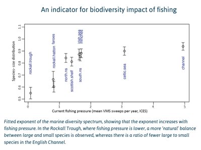
The variation and distribution of body size across species (diversity spectrum), with small species being more frequent than larger species, has caused ecologists to ponder on the mechanisms behind the precise shape of the relationship and also whether it might help inform management understanding. MERP scientists explored whether if using food-web theory they could accurately predict the shape of this diversity spectrum and whether it could be used as an indicator of fishing pressure for use in forming management initiatives. To test predictions they used a large dataset of marine animals from around the UK: this included mammals, birds, and a range of invertebrates, as well as fish. The scientists also examined whether fishing pressure, in particular the impact of exploitation of large species, contributes to changes in the shape of the diversity spectrum. They revealed that above a lower size limit the diversity spectrum follows a power-law, and also found that the diversity spectrum steepens with increasing fishing pressure, over large marine regions as well as grid square scales. The scientists suggest that, through the use of food-web theory, not only can they predict the shape of the diversity spectrum, they can also apply the species-size exponent to capture potential local extinctions at a range of spatial scales, and hence now have an indicator of long-term pressures on marine systems.
Contact: Axel Rossberg
Modelling seabirds and their prey
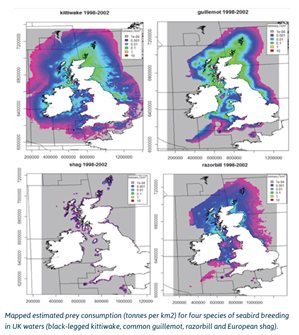 To fully understand and manage the complex mosaic of demands made upon our seas it is essential to determine how different activities proceed and potentially impact others. Seabirds are iconic members of the marine fauna, indicators of healthy seas, drivers of ecotourism and simply sources of a sense of well-being and wild nature. Seabirds themselves have significant impacts on marine foodwebs as top predators. MERP scientists investigated the impact that seabirds have on their prey by developing a modelling framework that translates the estimates of breeding seabird distribution into the amount of prey removed from the marine system. The researchers concentrated on five seabird species, which between them make-up around three-quarters of the seabird breeding mass in the UK: black-legged kittiwake, common guillemot, razorbill, European shag and the northern gannet. For each species a state-of-the-art predation pressure map, spatially resolved to 1km was produced from GPS tracking data; these maps allow individuals to be linked back to their colony location. These distribution and pressure maps relate to breeding populations in SPAs, including the MERP case study areas in Cardigan Bay and the South West of England, areas which are subject to large number of local and visiting tourists.
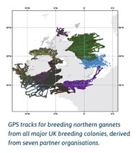 The research, and its resulting modelling framework, has made an important contribution to MERP objectives and will have strong relevance to stakeholders, such as statutory nature conservation bodies, responsible for understanding and assessing the responses of top predator populations to multiple humanactivities which impinge on predator populations and their behaviour. This study also draws together all available GPS tracking data for the northern gannet and applies models to map the habitat use of this most iconic of species around all major colonies occupying UK waters. The models have produced spatially explicit estimates of habitat usage and derived prey consumption around the UK for this ecologically important species.
Additional analyses carried out as part of MERP have highlighted the importance of understanding seabirds and the spatio-temporal diversity in their food resources. Variation in availability in time and space of forage species, and the ability of predators to exploit these is essential for their survival as it allows predatory seabirds to buffer against resource scarcity and environmental stressors such as extreme weather. Results suggest that such a mechanism exists in the seabirds studied and offers potential benefits for marine organisms that face predicted increases in extreme climatic events, increasing impacts from long-term climate change and other impacts from overfishing, pollution and competing activities in the offshore environment such as renewable energy developments. The researchers suggest that encompassing areas of spatio-temporal variation into Marine Protected Areas would enhance the future survival of top predators, which is of prime importance in safeguarding our seas. This work is due to be published in scientific literature in 2019. Contact: Kate Searle
Risk Maps
Another aspect of MERP activities has been the continued progress on risk mapping of top predators. Models produced earlier in MERP have been refined with improved temporal and spatial resolution of seabird and cetacean distributions. These are now presented as robust monthly distribution maps, with <10km resolution maps being particularly useful when mapping risk, where activities have a localised footprint, offshore energy installations for example. Further refinement and re-emphasis has meant that primary risk factors, such as fisheries conflicts (notably bycatch), vessel (primarily shipping) strikes and both continuous and pulsed noise disturbance, have also been mapped. Estimating the risk of vessel strike requires good data on shipping resolved by vessel speed, as those moving at speeds above 10 knots are more likely to cause serious or lethal injury on impact. AIS and VMS data are being characterized to produce high resolution vessel movement information, for the production of maps.
Contact: James Waggitt or Peter Evans
Fishing Impacts
Part of MERP’s activities concerned the processing and mapping of fishing activities by gear type and month, using data sets from ICES and Global Fishing watch. The data is obtained from AIS and VMS, however neither method is comprehensive, both have limitations, with the potential to reach different conclusions. MERP researchers have been looking at why these discrepancies exist and investigating ways of effectively combining the two data sources. If this can be overcome to provide a comprehensive and representative data set, mapping of fishing effort by gear type, by month and by target fish species will be available. So far preliminary maps have been produced of bycatch risk, on cetaceans and species of seabirds, of different gear types. Further refinements are ongoing to quantify fishing effort, identify target fish species in different fisheries to inform more detailed mapping of risk.
Contact: Mike Heath
Models for Management
Development of the MERP model ensemble alongside the Bayesian Belief Network approach to modelling has been ongoing throughout the MERP project since its beginning. While these developments apply more specifically to other parts of MERP, major progress has been made in statistical methods for building multi-species models to address management questions, resulting in a paper: ‘Avoiding the curse of circularity: building a multi-species model from the ground up’; this approach is in perfect harmony with MERP aspirations and is due to be published in 2019.
The Common Fisheries Policy, exploited ecosystems and Good Environmental Status
In parallel, there has been further development of individual ecosystem models, notably the improvement in coverage of top predators in the top-down, bottom-up Ecospace coupling for the west coast of Scotland. Traditionally fisheries management has looked at single fish stocks, now the latest reform of CFP has moved regulation toward Ecosystem-Based Fisheries Management (EBFM), while the MSFD dictates that Good Environmental Status (GES) should be achieved by 2020. MERP researchers set out to see whether the CFP could achieve GES, by applying an EBFM approach to the demersal fishery to the west of Scotland – a fishery with depleted cod and whiting stocks, increased predation from grey seals and a large bycatch of juvenile whiting. A food web ecosystem model simula¬ted the outcomes of applying the traditional single stock fishing mortalities and management scenarios that explored fishing mortality ranges in accordance with the CFP. Results highlight the need to consider prey-predator interactions, especially the impact of cod and saithe, on juvenile cod and whiting. It is suggested that using the single stock approach is likely to recover cod, but not whiting; for whiting to recover a drastic reduction in juvenile whiting bycatch is necessary. It was also noted that grey seal predation had little impact overall, despite affecting the timings of cod and whiting recovery. While there was little difference observed between the single stock scenario, and the best scenario for achieving GES, the findings do indicate that ecosystem modelling should be used alongside the traditional single stock approach. Similar work is in progress for the Celtic Sea model.
Contact: Natalia Serpetti
Direct stakeholder input to risk-based Cumulative Effects Assessment
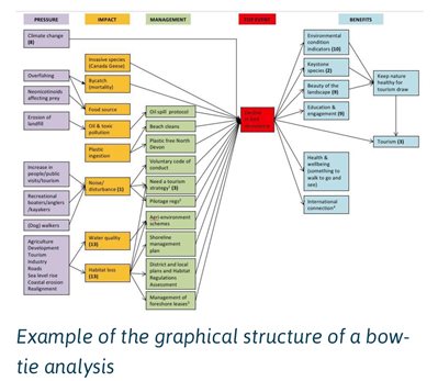 Bow tie analysis (BTA), so-called because of the shape of the resulting layout, is a graphic method of simplifying complex series of events for wider understanding by stakeholders. In MERP, BTA was trialled twice for both engagement and for incorporating stakeholder expert knowledge into cumulative effects assessment. During a stakeholder workshop in Cardigan Bay stakeholders worked together to define issues and activities of concern in the area. For each of the identified main issues: identifying impacts/consequences of the issues; identifying the causal factors or threats associated with the issues, and identifying preventative or remedial actions were agreed. These provide the basis to build the bow-tie straight with the stakeholders during the workshop and so demonstrated an immediate representation of issues, causes and potential management solutions. This was the first time that BTA had been used in a ‘live’ situation to collate stakeholder knowledge and experience. As with any new approach lessons were learned, such as ensuring the top level event is well defined before a workshop takes. BTA was also trialled at the 2nd Marine Pioneer stakeholder workshop. 50 representatives from a wide range of sectors developed bow-ties for two locally important issues – declining bird populations and poor water quality. The approach allows for pressures, impacts, management measures and the benefits of mitigation for each context to be rapidly identified.
This MERP work informed a second stakeholder workshop in Norway for OSPAR, so taking MERP work from local to regional, and has been instrumental in the application of the indicator, risk-based methodology for CEA (using BTA as a tool) that is being applied in the OSPAR QSR 2023 and UK Marine Strategy. Contact Adrian Judd: adrian.judd@cefas.co.uk