menu button

Addressing Of Policy Questions By MERP

Analysis of results and publication of research can continue after research programmes finish, however, already MERP has produced outputs that are or have the potential for use within the policy and/or management setting, such as in OSPAR (MSY), MSFD (GES), the new CFP, ICES, Habitats Directive, Birds Directive, as well as the recently published marine section of the report, 'A Green Future: Our 25 Year Plan to Improve the Environment’. As more papers are published and taken up by relevant stakeholders the impacts of MERP will become more widespread and influential for many years ahead. Some model contributions are included here, other less obvious but no less important model outputs and developments are reported through scientific papers - a full list is available via the MERP website.

This interactive infographic provides a broad overview of how MERP research fits with policy questions. Clicking one of the three categories below will take you to specific questions and show how MERP has addressed them.

  • Are we achieving Good Environmental Status (GES) for MSFD descriptors1,4 and 6 at regional scales?

    Descriptor 1. Biological diversity is maintained. The quality and occurrence of habitats and the distribution and abundance of species are in line with prevailing physiographic, geographic and climatic conditions.

    Descriptor 4. All elements of the marine food webs, to the extent that they are known, occur at normal abundance and diversity and levels capable of ensuring the long-term abundance of the species and the retention of their full reproductive capacity.

    Descriptor 6. Sea-floor integrity is at a level that ensures that the structure and functions of the ecosystems are safeguarded and benthic ecosystems, in particular, are not adversely affected.

    A report has been submitted to the EU on interaction between GES indicators based on StrathE2E. EU has accepted the functional group aggregations in StrathE2E as an operational basis for assessing food web GES. Development and testing of Typical Length as an indicator for fish community status continues: adopted by OSPAR as main indicator to asses fish diversity; IPBES are planning to use this indicator in assessment of “Biodiversity and Ecosystem Function in Europe and Central Asia”. Contact: Mike Heath

    Indicators derived from the outputs of StrathE2E, Ecosim, contingent monetary valuation models, and the non-monetary valuation data analysis are being incorporated into the developing Cefas CefMAT web application, a tool which will allow users to interrogate integrated data and generate visualisations corresponding to scenarios of their own construction. These will be geared to aiding decision making in relation to MSFD and OSPAR assessments. Contact: Mike Heath

    New data and R tools developed in the programme are now accessible through the Marine Ecosystems Research Programme GitHub repository. This provides a simple ‘research-grade’ interface to access, manipulate, and display UK marine biodiversity data. The data accessed via these tools involved input from multiple MERP partners.

    For many applications it is crucial to know the traits of marine species, for understanding ecosystem function and building ecosystem models. We are still a long way away from complete characterization of every species, but the MERP Trait Explorer addresses this issue. Trait Explorer is publicly available and represents a step-change in estimating traits for species.

    In collaboration with scientists from various ICES countries, MERP scientists have been using traits-based data, brought together through MERP (e.g. Trait explorer) and other nationally- and internationally-funded initiatives, to support activities of the ICES Working Group on Biodiversity Science (WGBiodiv). Contact: Jorn Bruggeman

    The potential of using cetacean and seabird long-term survey data sets for trend analysis in relation to Descriptor 1 (Biodiversity) is being investigated.

    A new size-based indicator has been developed, based on the observation that small species are more frequent than large species, formalised in the ‘diversity spectrum’. Contact: Axel Rossberg

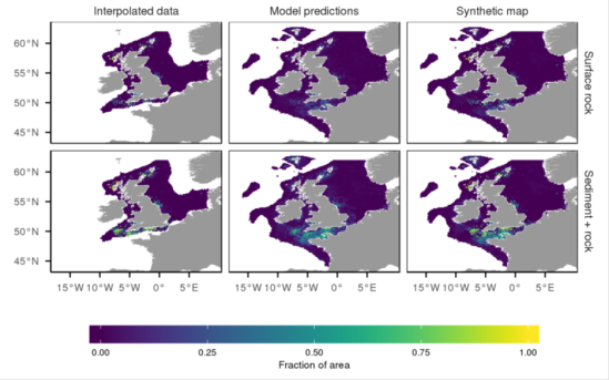
    Spatial data on the nature and composition of the seabed are crucial. MERP has brought together international datasets of sediment composition, grain size, and carbon and nitrogen content; this covers a large part of the NW European shelf. The gridded data products are available as maps of: Derivation of the synthetic maps of area-proportions of exposed bedrock, and of rock covered by up to 5cm of sediment.
    Invasive ecosystem engineers (IEE) are potentially one of the most influential types of biological invaders. They are expected to have extensive ecological impacts by altering the physical-chemical structure of ecosystems, thereby changing the rules of existence for a broad range of resident biota. MERP found that IEE had a significant effect (positive and negative) in most studies testing impacts on individual species, but the overall (cumulative) effect size was small and negative. The clear effects of IEE on ecosystem functions suggest that scientists and environmental managers ought to examine how those effects might be manifested in the services that marine ecosystems provide to humans. Contact: Ana Queirós

    MERP investigated how infaunal structure varies with mesh size, sample size and sample dispersion within a muddy sand and a coarse sand. The MERP study showed the biology of marine metazoan benthos does not scale continuously across the full range of taxa and body size as has been recently suggested, but may do so for individual taxa and restricted size ranges.

    To identify changes in UK pelagic habitats, plankton lifeform groups were constructed based on biological traits, using diverse UK data sets collected by different methods, including plankton sampling by nets, water bottles, integrating tube samplers, and the Continuous Plankton Recorder. This is the first time that the pelagic plankton community has been assessed on a UK-wide scale and forms the foundation of the UK’s 2020 MSFD Assessment for pelagic habitat biodiversity. This approach revealed that some of the plankton lifeforms used in the assessment displayed spatially-variable changes during the past decade.

    Data from the Poseidon/Peltic cruises in the SW approaches to examine the environmental drivers of dominant pelagic fish of the Celtic Sea and western Channel suggest that temperature plays an important role in driving both anchovy and sardine distribution with phytoplankton and frontal features also playing an important role.

    MERP examined 275 time points collected at weekly resolution over 6 years at station L4 in the Western English Channel. Despite order of magnitude variability in the mean biomass of key functional groups across years, the total planktonic biomass (from picoeukaryotes to fish larvae) varied only twofold.

    MERP has developed an integrated 28-year time series of zooplankton biomass and traits from the Plymouth L4 station, 1988-2015. This value-added L4 zooplankton time series was used by the UK Pelagics Expert Group in the OSPAR 2017 intermediate assessment for one of its three pelagic indicators, namely PH 1: Planktonic Lifeforms. Contact: Angus Atkinson

  • Are we achieving Conservation Objectives for species and habitats at local MPA scales?

    Very little attention has been paid to functional diversity in marine ecosystems and even less research has focused on the effectiveness of MPAs for the conservation of functional diversity; its application to conservation has been held back by a lack of data. A MERP study aimed to assess the effectiveness of Scotland’s MPA network in protecting functional diversity by bringing together new datasets on Scotland’s functional diversity and MPA management.

  • What is the relationship between ecosystem services and GES?

    Estimates of macroalgal subsidy drew on a combination of model estimation of biomass and production scaled up to whole coastlines. The work shows that around 50% of Scotland’s carbon dioxide emissions may be offset by addition of carbon to long-term stores, with kelp contributing up to 30% of the supply of carbon to the seabed. Emerging patterns suggest that the expected distinct patterns of decay in biomarkers with distance were not evident, and that tidal mixing at the main locations sampled (Plymouth, Anglesey, Northern Ireland) may have rapidly dispersed kelp-derived particulates. Contact: Mike Burrows

    Estimates of biomass and organic carbon production at the level of individual MPAs are contributing to the development of informed management and conservation strategies. MERP-produced models have also been used in estimating kelp biomass and extent around Scotland. Contact: Mike Burrows

    The critical level of chlorophyll a is already exceeded in some UK marine systems and global warming is expected to enhance them further. A new size-spectrum model developed by MERP explains and demonstrates the causal chain: nutrient enrichment - bottom-up trophic amplification - gradual consumer satiation - top-down effects - dome formation. MERP Partners measured marine size spectra in various parts of the Celtic Sea. With improved data, the present research allows us to mobilize this data to address management questions, such as to determine to what extent the Celtic Sea ecosystem exhibits signs of trophic amplification, top-down cascades, and dome formation. A new model (the nonlinear Species Size Spectrum Model, SSSM) has been designed and implemented. Contact: Axel Rossberg

    MERP considered whether a selection of GES indicators related to biological descriptors, D1 Biodiversity, D2 Non-indigenous species, D4 Food webs and D6 Seafloor integrity, may provide information relevant to ecosystem services, potentially allowing use of collected environmental data for more than one purpose. By highlighting the comparability between ecosystem service and biodiversity indicators it is hoped that future monitoring effort can be used not only to ensure that GES is attained, but also that ecosystem service provision is maximised. The research has been published (Broszeit S et al (2017). What can indicators of good environmental status tell us about ecosystem services?: reducing efforts and increasing cost-effectiveness by reapplying biodiversity indicator data. Ecological Indicators 81: 409-442 doi: 10.1016/j.ecolind.2017.05.057). Contact: Stephanie Broszeit

  • Identification of areas of particular importance to fish populations.

    Juvenile fish can tolerate both warmer average and a wider range of water temperatures than adults, meaning adults have been hypothesised to show greater sensitivity to increasing ocean temperatures. Although latitudinal range shifts were observed for both adults and juveniles, the average distance between the distributions of adults and juveniles of the same species had shown no change through time, demonstrating that connectivity between juvenile nursery habitats and adult populations has not thus far been affected by climate induced range shifts. These results demonstrate that adult and juvenile fish are differing in their responses to climate change, and that further research is needed to better quantify what causes these differences in response.

    A reference sequence database of common local fish species at L4 Station (Plymouth) has been compiled, facilitating the correct taxonomic annotation of unknown amplicon barcodes to local species. Contact: Angus Atkinson

  • How can we define and describe biodiversity hotspots?

    MERP has developed predation pressure maps, spatially resolved to approximately 1km, which represent the state-of-the-art in quantitatively estimating seabird distributions from GPS tracking data. These maps allow for observed individuals in a given area of sea to be linked back to their colony of origin, in contrast to methods that use at-sea survey data where the provenance of an individual cannot be explicitly known. Contact: Kate Searle

    Hotspots for species richness and taxonomic diversity were located and compared to assess congruence between different taxonomic groups and measures of diversity. There was considerable overlap in the hotspots of 10 major taxa, with 84.2% of hotspots overlapping with at least one other taxonomic hotspot, and 50.2% overlapping with 4 or more. Randomised sampling of UK waters revealed that the existing network represented more species and hosted significantly greater mean taxonomic diversity than if the network was randomly allocated across the UK exclusive economic zone. Contact: Kate Searle

  • How are populations of vulnerable species (cetaceans, seabirds, elasmobranchs etc) distributed in space and time?

    MERP has developed risk mapping of top predators. Models have been refined to improve the temporal and spatial resolution of distributions of seabird and cetacean species, as robust monthly distribution maps and maps with resolution <10km are particularly relevant for mapping risk for activities having a localised footprint - e.g. effects of offshore renewables. Mapping has also been undertaken for primary risk factors including fisheries conflicts (notably bycatch), vessel strikes (primarily through shipping), and noise disturbance (both continuous and pulsed sounds). Contact: Kate Searle

    Distribution maps of the most common seabird and cetacean species on a seasonal basis are being produced from processed and standardised collation of at-sea surveys covering appx. 3 million kilometres and 30 years. The data will allow a quantitative comparison with human pressures known to impact cetacean and seabird species, at fine spatial and temporal scales. Contact: Peter Evans

  • Where do key foraging areas for seabirds occur in space and time?

    MERP has developed novel baseline understanding of the spatial habitat use and predation pressure of ecologically important marine top predators. This knowledge may be combined with other data and models to better understand how ecosystem processes and the services they support, such as wildlife tourism, operate against the background of environmental change both now and into the future. Analysis of seabird space-time distributions is a transformative advance. Contact: Kate Searle prey consumption map

    Work focusing on northern gannets, has drawn together all available GPS tracking data for this species and applying models to map the habitat use of this iconic species around all major colonies occupying UK waters. These models provide spatially explicit estimates of habitat usage and derived prey consumption around the UK for this ecologically important species. Contact: Kate Searle prey consumption map GPS tracks for breeding northern gannets from all major UK breeding colonies, derived from seven partner organisations. Effect

    Conservation organisations have identified diet as an important gap in their knowledge of our seabirds and from discussions with the RSPB it appears that this diet information will be a very important contribution to their conservation and management planning for seabirds. MERP has constructed, and continues to populate, a comprehensive time- and spatially-explicit database of diets for the 10 most important seabird species (with respect to biomass) of the British Isles. This contributes to understanding the regulation key ecosystem services by top down and bottom up processes and exploring the impact of environmental change and potential management solution on the structure, function and services associated with marine food webs.

    Maps have been produced that highlight populations most likely to be particularly sensitive to changes in the marine environment such as the development of offshore renewable energy. This research provides empirical evidence for how density dependent processes in upper trophic levels are affected by environmental variation in both biotic and abiotic factors. Spatial maps of predicted density dependent population growth for each of the 11 species will be made publicly available. This understanding may be combined with other data and models to better understand how ecosystem process and the services they support, such as wildlife tourism, operate against the background of environmental change both now and into the future

    The probability of encountering foraging seabirds was highest around fronts between mixed and stratified water. Prey were denser and shallower in mixed water, whilst encounters with prey were most frequent in stratified water. Therefore, no single measurement of increased prey availability coincided with the location of fronts. However, when considered in combination, overall prey availability was highest in these areas. These results show that top predators may select foraging habitats by trading-off several measurements of prey availability. Contact: James Waggit

Back to home
  • How does the removal (e.g. by tidal lagoon projects etc.) or alteration (e.g. by towed fishing gears) of benthic habitats affect populations of marine mammals and birds (mammals and birds included in the Habitats Directive)?

    Fishing activities were processed and mapped by gear type and by month using two different data sets (one from ICES, the other from Global Fishing Watch). These rely upon either AIS or VMS data; neither method was comprehensive and both had other limitations, resulting in different conclusions. The causes of these discrepancies, and strategies for effectively combining the two sources, were examined with the aim of mapping fishing effort by gear type, by month, and by target fish species using as comprehensive and representative a data set as possible. Preliminary maps have been produced of bycatch risk of different gear types on cetaceans and seabirds (by species).

    Knowledge of feeding rates is essential for many forms of modelling of relevance to understanding marine ecosystems. A study formed part of a larger data gathering exercise which sought to increase globally available data on benthic consumer feeding rates to develop a benthic consumer functional response dataset. Previous meta-analyses incorporated ~50 benthic consumer functional response data points. The entire dataset will be made available via open access publication.

  • What are the impacts of removal or change of fish prey species on marine bird and mammal populations (Habitats and Birds Directives)?

    Work on top predators, once published, will have strong relevance to stakeholders (including statutory nature conservation bodies) responsible for understanding and assessing the responses of top predator populations to multiple human activities impinging upon predator populations and behaviour (e.g., offshore renewable energy developments, commercial fishing). Contact: Peter Evans

    Preliminary maps have been produced of bycatch risk of different gear types on cetaceans and seabirds (by species). Refinements are ongoing to improve the quantification of fishing effort, identify target fish species of different fisheries for more detailed mapping of risk, and identify country of origin of fishing effort by gear type.

  • Evaluate cumulative impacts, to allow for ability to strategically assess the capacity of cetaceans and seabirds to cope with cumulative impacts across their ranges.

    Vessel data rely upon AIS or VMS, and these data were secured, allowing characterisation of vessel movements at high resolution. These are now being classified by vessel type and speed to derive maps of risk of ship strike for different cetacean species.

    Mapping the distributions and predation pressure of top predators underpins and informs interactions between wildlife and human activities. Energetics modelling, developed in MERP, now allows combining with adult and chick survival to estimate prey intake per hour of foraging. Species-specific estimates in preparation for applying the energetics framework, together with the utilisation maps, to produce spatially explicit predation pressure maps for these three important species in UK waters is underway. Maps are being constructed to enable more informed assessment of key habitat areas with likely strong trade-offs between competing wildlife and humans. Contact: Kate Searle

  • How do impacts on rare and/or threatened habitats and species affect ecosystem services?

    Work on non-monetary valuation of marine ecosystems demonstrates the central importance of red-listed seabirds and mammals in marine users’ shared cultural values. Contact: Mike Heath

Back to home
  • What are the effects of changes in fisheries management on the environment, particularly through food-web effects?

    Working with participants from across the MERP consortia, a conceptual model was developed to link MERP’s four local marine ecosystem services (food provision, bioremediation of waste, leisure and recreation, biological checks and balances) to ecosystem processes and components of the ecosystem to identify key linkages and to help visualise trade-offs between services. The models provide a useful framework to discuss the effects of management options with stakeholders and managers. They are now being developed into statistical models to develop a quantitative approach to ecosystem service management, using a variety of MERP data. It is an important step towards quantitative assessment of services which can help communicating with policy makers, and has been used for stakeholder workshops. Contact: Mike Heath

    The issue of trade-offs between fishery yields and management measures, and MSFD status is at the heart of both MERP and the issues around discarding. Discarding is just a part of the story about how fisheries affect ecosystems. There are two potential ways of achieving reductions in discarding: 1) carry on catching as usual but bring everything ashore; 2) improve the selectivity of fishing gears so that unwanted fish are no longer caught. The research using the StrathE2E model showed that ‘bring everything ashore’ had only very small effects on the food web implying that, overall, discards were a trivial contribution to food supply for the food web. Such impacts as there were, were mostly negative, affecting the abundance of scavengers. In contrast the ‘improved selectivity’ strategy had very large impacts on the ecosystem due to the effective reduction in harvesting rates. This created a strong trophic cascade with generally positive effects for fish and top predators. This is strong evidence for implementing a policy of concentrating fishing effort in the most highly impacted areas, which contrasts strongly with advice from conservation organisations that, as the potential for recovery is strongest in the most highly impacted areas. Contact: Mike Heath

    There are many more smaller than large species. Previous studies have indicated that the distribution of adult body lengths or masses of species in aquatic communities (the “diversity spectrum”) follow power laws. While the Large Fish Indicator and the recently introduced Typical Length provide good indicators for the status of the size spectrum, there is currently no corresponding indicator for the status of the diversity spectrum. MERP research combines data generated and/or mobilized by MERP Partners with theoretical and statistical analyses. Findings may be used to predict the impact of potential management solutions, such as reductions in fishing pressure or marine conservation zones, on biodiversity across body-size scales. Contact: Jorn Bruggemanm

    Both Ecosim and StrathE2E combine sub-models of ecology and fishing fleets, the coupling is typically one way with no return feedback, by which the simulated ecological conditions and fishery landings and discards affect subsequent activities of the fishing fleet. This two-way connection feedback process was impossible in Ecosim, but is possible for StrathE2E. Contact: Mike Heath

    The results of MERP research cruises show that fishing bottom trawling pressure has greater impacts effects on the size spectra on benthic ecosystems in areas of high primary production. Contact: Leigh Howarth

    Using fuzzy coded biological traits, a recently published study based on data from the MERP cruises (Howarth et al. 2018 Marine Ecology Progress Series 602: 31 – 48) compared the functional composition, diversity and evenness of benthic communities in the English Channel and in the Celtic and Irish Seas across interacting gradients of bottom trawling and primary production. Because trawling affected some traits more than others, community biomass was less evenly distributed across traits in highly trawled areas, which resulted in lower levels of functional diversity and evenness. Overall, the effects of bottom trawling were greater in areas of high primary production. Contact: Leigh Howarth

    Samples of fish stomachs collected during previous MERP/Poseidon research cruises (between 04/10/2015 – 20/10/15) have now been analysed using sophisticated genetic identification techniques; over 20% of all mackerel were shown to have recently consumed jellyfish (mostly Pelagia noctiluca), along with lower frequency of occurrence in sardine and sprat. Molecular analysis of fish larvae and jellyfish gut contents from Station L4 have been used to elucidate trophic interactions. Fish consume jellyfish, but jellyfish consume juvenile fish: there are complex interactions between these two taxonomic groups which we now understand in more detail. Contact: Angus Atkinson

    MERP developed a new method of combining surveys to estimate life history parameters. The paper (Spence MA and Turtle AJ, Making the most of survey data: Incorporating age uncertainty when fitting growth parameters, Ecology and Evolution 7(17) 7058–7068) demonstrated a method that reduced the uncertainty in estimates of the von Bertalanffy growth parameters by considering the spawning time of the species. The work demonstrated a way of quantifying the uncertainty for inputs to models used to advise policy makers. Contact: Mike Spence

    Working with partners at a European scale (Peck et al. 2018 Estuarine, Coastal and Shelf Science doi: 10.1016/j.ecss.2016.05.019), reviewed and compared four broad categories of spatially-explicit modelling approaches currently used to understand and project changes in the distribution and productivity of living marine resources including: 1) statistical species distribution models, 2) physiology-based, biophysical models of single life stages or the whole life cycle of species, 3) food web models, and 4) end-to-end models. Single pressures are rare and, in the future, models must be able to examine multiple factors affecting living marine resources.

    A new implementation of the size-structured fish model MIZER that can be two-way coupled to ERSEM, and run within high resolution spatial models, has been implemented. This brings two key advances: feedbacks between lower and higher trophic levels are fully represented, and spatial fish distributions are captured in detail on the NEMO-ERSEM grid. Contact: Mike Spence

    Previously the linked ecology and fishing fleet StrathE2E involved only one-way coupling – the fishing fleet model provided input to the ecology model, but the ecology model could not return any information to the fishing fleet model. A system has been developed to include the two-way feedback between the two parts of the system. Contact: Mike Heath

  • What are the responses of indicators to specific management measures for MSFD descriptors?

    Indicators derived from the outputs of StrathE2E, Ecosim, contingent monetary valuation models, and the non-monetary valuation data analysis are being incorporated into the developing Cefas CefMAT web application, a tool which will allow users to interrogate integrated data and generate visualisations corresponding to scenarios of their own construction. These will be geared to aiding decision making in relation to MSFD and OSPAR assessments. The full suite of module 7 data outputs will be available for the west of Scotland ecosystem. TLR contingent valuation model results and non-monetary assessments will also be available for the southwest of Britain, and Strathe2E results for the North Sea.

    MERP research showed a dynamic coupling between the ecology and fishing fleet sub-models of StrathE2E in which: costs of individual gear types increased with activity, operating distance from shore and density of competing gears; revenue of individual gears increase with landings; subject to any spatial exclusions (mimicking protected areas, for example) individual gears redistribute their effort dynamically in space to be proportional to recent profitability. This implies if recent profit proportion is positive, activity will increase and vice versa. If this control is used alone this is an ‘open access’ fishery driven by market forces. If recent biomass for each resource group is greater than a management threshold target, then activity can increase, and vice versa. Further, a range of alternative regulatory controls are possible including activity limits and intensity of seabed abrasion, or by catch of non-target groups, birds or cetaceans, for example. Contact: Mike Heath

    Model runs with any given set of prices for each resource group, cost-scalings for each gear, and management targets converge to stable solutions in terms of gear activity rates and distributions in space, and ecological states – these are emergent solutions not easily predictable.

    Fitting complex and computationally demanding ecosystem models to data, to get accurate parameter estimates and to track uncertainty, is a challenge that needed to be addressed before developing the ensemble framework. MERP researchers developed new methods (Spence et al, 2016, Canadian Journal of Fisheries and Aquatic Sciences, doi.org/10.1139/cjfas-2015-0022) that allow dynamic ecosystem models to be fitted to time series data, rather than time-averaged data, and permits efficient exploration of high-dimensional parameter spaces. Contact: Mike Spence

    MERP work (with the University of Tasmania) shows how novel statistical methods can be used to synthesize predictions from varied ecological models, making the most of their different strengths. It incorporates two case studies using models within MERP, illustrating the relative recovery speeds and uncertainties for indicators, and the long-term values, dependencies and uncertainties in biomasses under particular management regimes. By synthesizing a range of models within MERP, this work gives a means of using them to explore effects of environmental change (objective 2) and of management strategies (objective 3) and the dynamics of indicators (objective 3). Cefas is now making substantial use of the ensemble approach, directly as a result of work in MERP. In particular, they are working on using ensemble modelling to combine single- and multi-species models, to obtain accurate, coherent projections over a range of time-scales. Contact: Mike Spence

  • What are the future changes in ecosystem services in response to different management scenarios?

    ‘Evidence Chains’, closely linked to Impact Chains, have been produced for seabirds using a range of evidence. Evidence chains provide a description of the linkages and interactions between natural capital assets and ecosystem services and human benefits, and are a useful step to link together the multiple impacts and outcomes required in cumulative effects assessment. A conceptual framework has been established for linking natural capital assets to human well-being, identifying and providing an evidence base for each step along the chain. Evidence for impacts of offshore renewable energy on seabirds has been collated and strength-assessed. This information will be made available to stakeholders through the NERC CEH Natural Capital Portal, which should be online by early 2019. Bow-tie analysis (BTA) has been appraised as a means of assessing cumulative effects. A paper has been written incorporating case studies on pollution from plastics, TBT and other contaminants affecting seabirds. BTA was also used during stakeholder engagement and incorporation of stakeholder knowledge for cumulative effects assessments. Contact: Adrian Judd

    A key component of natural resource management is understanding the implications of changing levels of pressures on ecosystem components, which is achieved through sensitivity assessment. MERP research (Hooper T, Beaumont N, Griffiths C, Langmead O, Somerfield PJ (2017) Assessing the sensitivity of ecosystem services to changing pressures. Ecosystem Services 24: 160-169 doi: 10.1016/j.ecoser.2017.02.016) examined how sensitivity assessment could be applied to ecosystem services, as opposed to the underlying habitats and species, by considering the relationship between the sensitivity of a service to the sensitivity of the habitat responsible for its supply. Contact: Tara Hooper

    Size-based indicators are used worldwide in research that supports the management of commercially exploited wild fish populations, because of their responsiveness to fishing pressure. Queiros et al. (Fish and fisheries 2018, doi:10.1111/faf.12278) used biogeochemical and mechanistic niche modelling of commercially exploited demersal fish species to project time series to the end of the 21st century for one such indicator, the large fish indicator (LFI), under global CO2 emissions scenarios. Modelling results, validated against survey data, suggest that the LFI's previously proposed policy target may be unachievable under future climate change. In turn, results help to identify what may be achievable policy targets for demersal fish communities experiencing climate change. Contact: Ana Queiros

    ERSEM is one of the most comprehensive biogeochemical models for shelf seas, but prior to MERP it remained a model of fixed complexity with a hard-coded number of functional types. Therefore it could not describe species that were not in the model and it could not systematically vary biodiversity. Within MERP, ERSEM has been rewritten from the ground up as a modular model. This lets ERSEM scale to potentially hundreds of types of zooplankton or benthic fauna, allowing it to be systematically diversified to assess the impact of diversity on ecosystem function. The new version of ERSEM allows us to model functional diversity and its effect on ecosystem functioning - and thus contributes to understanding the link between functional diversity and ecosystem services. The modular version of ERSEM (http://www.pml.ac.uk/Modelling_at_PML/Access_Code) has been publicly released. Contact: Jorn Bruggeman

    MERP scientists have combined research analysis with a synthesis of ecological impacts and then translated that into ecosystem services impacts. They show that marine plastics don't just impact ecology they can also have socio-economic impacts. The study estimates that there will be a 1-5% decline in marine ecosystem service delivery due to plastics in the ocean. That equates to an annual loss of $500-$2,500 billion in the value of benefits derived from marine ecosystem services, globally. Contact: Nicola Beaumont

  • What is the impact of multiple MPA closures on fisheries and recreation?

    Mathematical methods and model simulations showed how adoption of different policy options to implement new CFP affects fisheries yields. Choices of both objectives and management strategies can have tremendous impacts on yields. The current strategy will result in rather low yields.

    Also noted that with inadequate policy measures, inherent model uncertainty can result in undesired management outcomes.

    Work continues focussing on the impacts of alternative fisheries management approaches.

    Innovative research on the part kelp plays in coastal ecosystems has shown that not only is it an important carbon store, it also has an important role as a nutrient supply, even away from its beds. As such it has a value which should be considered in management scenarios.

Back to home
The interactive above gives an overview of how the programme has addressed policy questions. 

Visit the Policy and Management page to find out more information.

The interactive is best viewed on a desktop, if you have any issues with it displaying incorrectly you may need to use a more up-to-date browser such as Google Chrome or Mozilla Firefox